
In the summer of 1901, Edward P. Brennan, private citizen, went on vacation to Paw Paw, Mich., with an armload of Chicago maps.
He came back with a set of proposals that, in their way, were as important to the development of Chicago as the 1909 Plan of Chicago, written by Daniel Burnham and his co-author Edward Bennett.
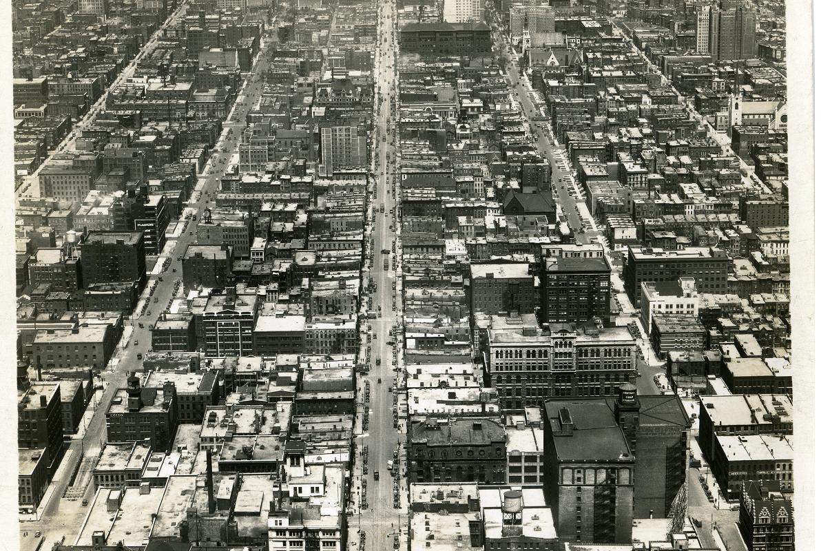
The goal of the Burnham Plan was to reshape the landscape of the city with new parks, a beautiful lakefront and a more efficient street system. To bring order to the physical world.
Edward Brennan’s idea was to reshape the mental landscape of Chicago residents and visitors. To bring order to their understanding and experience of the city.
When he got back from his vacation, Brennan wrote a letter to the Chicago City Council outlining his proposals --- and began a four-decade crusade that changed literally every corner of the city.
Brennan proposed making the city’s street system rational. He wanted to change the way streets were named and numbered so that residents and tourists could find their way around easily.
And, by needling the Council year after year, he made it happen.
Indeed, every time you make your way through Chicago’s streets and find it so easy to locate a street and track down an address, he deserves the credit.
Thank heaven for Edward Brennan.
A 35-year-old nobody
While Burnham and Bennett were of the Chicago power structure, Brennan was a 35-year-old nobody. He was a bill collector for Lyon & Healy Co. in the Loop with no financial or professional incentive to meddle in city policy. When it came to urban planning, he was a rank amateur.
Yet, he had an idea. And it was an idea that made great sense to him and to anyone living in Chicago at the time. And he was tenacious in pushing that idea.
Brennan recognized that planning wasn’t something for the experts. It was the responsibility of everyone.
To understand why the idea of rationalizing the city’s street system was so necessary, you need to understand how chaotic it was. And how difficult it was to get from one place to another.
In 1901, Chicago had 13 streets called Washington, 13 called Center and 14 called Park. It had nine Forest streets, nine Sheridan streets and 10 Oak streets. Seven were called 40th, and eight were named 42nd. There were even five named for former U.S. Vice President Schuyler Colfax.
Depending on the part of the city you were in, the street just west of Halsted was called Green Street, Lime Street, Dayton Street, Florence Avenue, Craft Street, Reta Avenue or Newberry Avenue.
As bad as that was, it was only part of the problem.
Between 1889 and 1893, Chicago annexed a huge amount of area, including the towns of Jefferson and Lake, the village of Hyde Park and the city of Lake View.
“Each annexed district kept its own numbering system,” Brennan explained once in a newspaper interview, adding, “A man had to spend half his time studying a street guide in order to be able to find his way.”
Five proposals
Brennan’s 1901 letter to the City Council had five main proposals:
(1) Rename hundreds of streets. Over the next 23 years, that’s what the aldermen did, giving new names to more than 1,200. At least 130 of those names, and maybe as many as 300, were suggested by Brennan.
(2) Establish a numbering system that used State and Madison as baselines. The Council agreed, and, on Sept. 1, 1909 --- just two months after the publication of the Burnham Plan --- the intersection of those streets became the nexus of the street grid. All numbers north, south, east and west proceed from 0 at that corner.
(3) Use a numbering system that would indicate how far a house address was from the base lines. Because of this, a system was imposed under which each 800 in an address generally indicates a mile. Thus, a home in the 6400 block of North Paulina Street is roughly eight miles north of Madison while a store in the 2400 block of West Cermak Road about three miles west of State.
(4) Use odd and even numbers to indicate the side of a street on which a house is located. Ultimately, the Council established that odd numbers are on the east side of north-south streets, and even numbers on the west side. For east-west streets, odd numbers are on the south side, and even numbers on the north side.
(5) Use street names beginning with the same letter to designate north-south streets within the same mile as an indication of how far west they are of State Street. This resulted in the streets between Crawford Avenue (now Pulaski Road) and Cicero Avenue being rechristened with names beginning with K, such as Keeler and Karlov. Further west, there were the L streets, then the N streets, then the O streets, such as Oketo.
Easy to find
Twenty-four years ago, one of Brennan’s daughters, Mary Brennan McGraw of Manteno, Ill., wrote that her father approached his long crusade with great zest and humor: “One time I remember him saying that if the city would pay him $1 a year, he could do more faster!”
One city official estimated that, during a 35-year period, Brennan attended 600 City Hall meetings to lobby for his proposal.
In 1937, the Council passed a resolution honoring him. But a newspaper editorial wryly suggested that the act didn’t so much arise out of gratitude but “a sense of relief at the removal of Mr. Brennan’s tireless pressure.”
Brennan died five years later. And, five years after that, the aldermen gave him a most appropriate honor --- they named a two-block-long street for him.
So, if you drive down to the Merrionette Manor subdivision, you’ll discover Brennan Avenue at 2300 East between 96th and 98th Streets.
It’s easy to find.
For a print-friendly version of this post, go here.
Blog Categories
- art (14)
- civic engagement (17)
- culture (16)
- future (26)
- green legacy (15)
- history (26)
- pavilions (4)
- schools (8)
- transportation (7)