
Last summer, when I was still a Chicago Tribune reporter, I interviewed Friends of the Parks president Erma Tranter about creating parks in the last four miles of lakefront now blocked from public use.
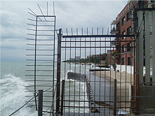
Chicago has 30 miles of lakefront, and 26 miles are covered in parkland. But two miles on the Far South Side and two miles on the Far North Side are in private hands or otherwise fenced off.
Friends of the Parks has been working with community residents as well as design and engineering experts to develop a detailed plan to close those gaps. In some cases, this would be done by obtaining lakefront property while, in others, lakefill would be used to create new parkland. You can see detailed maps of the gaps on the South Side here and on the North Side here.
Last month, after leaving the Tribune, I helped Friends put the finishing touches on its report, titled “The Last Four Miles.” It was published Tuesday after being previewed in the Tribune.
There is much that’s exciting about this idea.
A single lakefront park
Right now, we think in terms of individual lakefront parks, such as Jackson Park, Lincoln Park, Loyola Park and Rainbow Beach. That makes sense, especially north of Ardmore Avenue on the North Side where there are more than a dozen tiny, unconnected street-end parks.
But, once those four miles of gaps are closed, it will be possible to think of the lakefront system as a single 30-mile park.
With those gaps gone, you will be able to bike from Evanston to Indiana. You will be able — if you have the legs for it — to walk the length of the city along the shoreline. From any part of Chicago, you will be able to go east and find Lake Michigan.
Burnham’s dream
What’s also exciting is that the creation of this single 30-mile park would be the fulfillment of the dream that Daniel Burnham expressed a century ago in the Plan of Chicago. It’s a dream that generations of city leaders and citizens worked to bring about.
In 1909, when the Plan was published, Chicago had only six miles of lakefront parks. Now, there are 26.
Today’s lakefront park system is a legacy of earlier generations of Chicagoans. Completing the vision of a city-long shoreline park would be our legacy to future generations.
Most important, though, may be the idea of a park that runs from one end of Chicago to the other.
Sure, this park would be a great playground, a great source of rest and refreshment, a great tonic to the crush of urban life. And it would be a great postcard image of the city.
But, even more, it would knit the city together.
Chicago’s park
Right now, geography does a lot to keep Chicagoans apart. North Side/South Side, it’s the fact of Chicago life.
Very few physical things are shared by all city neighborhoods, mainly the expressway system and some long streets such as Western Avenue. Parks are local. Even the Loop and the Magnificent Mile are local places.
A single 30-mile long park from one end of the city to the other would be Chicago’s park.
It would be a new, unparalleled symbol of the city that Chicagoans share. And, more than a symbol, it would be the embodiment of the reality that, in fact, we do share the same city. We are one people.
One Park/One Chicago.
For a print-friendly version of this post, go here.
Blog Categories
- art (14)
- civic engagement (17)
- culture (16)
- future (26)
- green legacy (15)
- history (26)
- pavilions (4)
- schools (8)
- transportation (7)