
Second of four
It’s a map that, in its scale, breadth and vision, looks like it could have come out of Daniel Burnham’s 1909 Plan of Chicago.
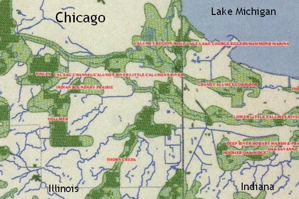
But the Chicago Wilderness Green Infrastructure Vision map (below and also available online) is as right-here-right-now as global warming. Indeed, it was created in response to that modern-day environmental worry as well as the many other ways that humans have been degrading the natural fabric in which we live.

The Plan that Burnham co-authored with Edward Bennett used a multitude of maps to get across the point that Chicago and the region around it --- everything within a 60-mile radius and beyond --- formed an interconnected landscape.
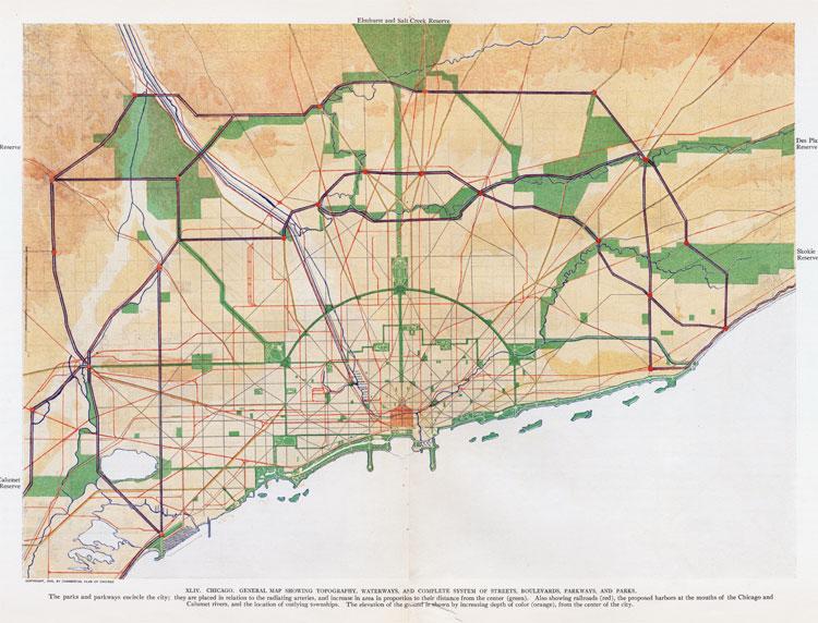 Here, a map showed the network of rail lines serving the region. There, another spelled out how a system of regional highways would make travel quicker and more efficient. A third (right) showed where a ring of forest preserves could be created to save Nature for the benefit of all of the region’s people.
"He who habitually comes in close contact with nature,” Burnham wrote, “develops saner methods of thought than can be the case when one is habitually shut up within the walls of a city….Human nature demands such simple and wholesome pleasures as come from roaming the woods, [from] rowing and canoeing, and [from] sports and games that require large areas.”
Those same psychological and esthetic considerations are at the heart of the Green Infrastructure Vision map. But also a lot more.
The green infrastructure already relieves some of the load on the “grey” infrastructure. For example, people don’t have to pay as much for flood control because natural areas, particularly those with native grasses and trees, soak up a lot of rainfall. By nurturing and expanding those natural areas, flood-control costs can be reduced even more.
In addition, a healthier nature means a healthier populace. “The green infrastructure improves our quality of life with better air quality, better water quality, better storm water management,” says Melinda Pruett-Jones, executive director of Chicago Wilderness, an alliance of conservation organizations.
"The region is shaped the way it is..."
The Green Infrastructure Vision map was completed in 2004, and Jeffrey L. Mengler, a botanist with the U.S. Fish and Wildlife Service, is the head of a task force that is working to promote it as an essential planning tool. Their goal, he says, is to have all 480 municipalities in the four-state Chicago region using the map routinely when making land-use decisions.
“The region is shaped the way it is because of Burnham’s Plan,” says Mengler. “A lot of us have that in the backs of our minds and see this as the next step in his vision.”
On the map, the Chicago region is shown in white with two shades of green laid on top. The dark-green shaded areas represent existing public open space, such as parks, forest preserves and other nature reserve. In all, these comprise about 370,000 acres of the more than seven million acres in the region.
The areas in light green are portions of the landscape that are important to the interconnected ecosystem --- about 1.4 million acres. As such, Chicago Wilderness and its partners are recommending that steps be taken to protect these areas.
Protection, though, doesn’t mean that the sponsors of the map are suggesting that all this land should become forest preserves --- although they’d argue that some should be set aside in this manner.
In some light green areas, development is likely to occur. (It already has in many places.) The point is that, if a new subdivision is planned within these sections, the particular environmental qualities of the land --- its help in flood control, for instance, or its habitat for a rare species of bird --- should be taken into consideration.
"Thinking about how we can live"
Chicago Wilderness says the Vision map “is not just a land acquisition strategy, but rather a call to carefully think about how we can live in and among natural areas in a sustainable way and to mutual benefit, by using tools such as conservation development, conservation easements, and thoughtful land use planning.”
Robert Dean, the principal regional planner for the Chicago Metropolitan Agency for Planning (CMAP), is working with Mengler’s task force to incorporate the map into his agency’s comprehensive regional plan, GO TO 2040.
This plan, up for approval in the fall of 2010, will be the first to integrate transportation and land use policies into a single document. And, unlike planning agencies that preceded it, CMAP has the power --- on paper, at least --- to reward projects that fit its plan and penalize those that don’t.
Dean says GO TO 2040 will recommend that local planners consult the Green Infrastructure Vision map when deciding how land is to be used. To make the map more useful, he has been urging the task force to make clear the reasons each light green area has been included on the map.
To that end, Mengler says, “Our goal is to have some electronic version of this map for every municipality in the area. The goal is to get the map to be part of their routine considerations.”
So individual electronic versions of the map for each municipality’s area have to be developed, and then, he says, it will be necessary to sit down with leaders in each city, town and village to explain the environmental importance of the local light green areas and how they might be addressed in the future.
“It’s a fairly daunting outreach task,” he acknowledges.
Of course, the task that Burnham set for himself and the other supporters for the 1909 Plan of Chicago was also daunting. Yet, much was accomplished.
The sponsors of the Green Infrastructure Vision map see it as a grandchild of Burnham’s Plan. “This is the next 100 years,” says Pruett-Jones.
And, if it takes that long --- well, even a century after its publication, there are still parts of the Plan of Chicago remaining to be finished.
Next: In your own backyard
For a print-friendly version of this post, go here.
Blog Categories
- art (14)
- civic engagement (17)
- culture (16)
- future (26)
- green legacy (15)
- history (26)
- pavilions (4)
- schools (8)
- transportation (7)